wardleymaps.com is for sale. Make an offer
Start mapping

From the read-only archive of the Wardley Mapping community forum (2018–2023). Category: Tools. Posts are by their authors. Links to sites that moved or closed point to link notes.

I’ve summarised [1] what my experiences with drawio for making Wardley Maps while taking into account, albeit briefly, the conversations that have been happening around it.

Consider it as another addition to the tools we use to make Wardley Maps.

[1] - https://juliusgamanyi.com/2019/03/25/wardley-maps-in-drawio

P.S. I think I’m getting the hang of gifs 😉😄

And a one click version

https://www.draw.io/?clibs=Uhttps://raw.githubusercontent.com/juliusgb/wardley-map-icons/master/drawio/WardleyMap-Icon-Library

Amazing, now all I need is a tutorial on how to create a map with draw.io

Oh, you want me to do that?

Sure, go ahead. Thank you.

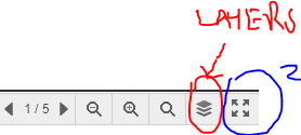
I don’t know if this might help you, but the way I’ve been using drawio is to use lots of layers - the first 2 layers being the Canvas and the Grayscale background. An example Map is here - http://wardleymaps.prototypes.001.gerstner.s3-website.eu-central-1.amazonaws.com/

To make the layers easy to navigate, I add buttons to the map that work well when zoomed in (see #2 below)

image

Feel free to ignore the example if you judge it to be not useful, or way too much, for your purposes 🙂